Mpala Area Maps
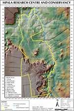
Map of Mpala Research Centre and Conservancy
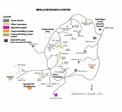
Map of the Mpala Research Centre Campus
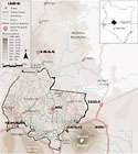
Map of the Ewaso Ecosystem
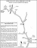
Map and Directions to MRC from Nanyuki (Courtesy of Matthew Durling)
(dataset taken from the AVHRR dataset from U. of Maryland)
Elevation of Laikipia
(dataset from SRTM-90 data, NASA)
Vegetation of Laikipia
(dataset from MRC)
Weather Forecast Pages
Long term forcast for Mpala Farm
Mpala Farm, Kenya Page
Rainfall Maps
(Rainfall dataset consist of 70 gauges around the basin measuring daily total rainfall with approximately 40 years of record (1960-2002))
mm/yr over Laikipia
Mean Rain Total (Jan-Feb)
Mean Rain Total (Mar-May)
Mean Rain Total (Jun-Sep)
Mean Rain Total (Oct-Dec)
Temperature Maps
(datasets consists of 3-14 gauges around the basin measuring daily values with approximately 15 years of record (1988-2002). Mean and +/-1 s.d. are plotted)
Daily Temperature (Jan-Feb)
Daily Temperature (Mar-May)
Daily Temperature (Jun-Sep)
Daily Temperature (Oct-Dec)
Storm Maps
(datasets consists of 3-14 gauges around the basin measuring daily values with approximately 15 years of record (1988-2002). Mean and +/-1 s.d. are plotted)
Avg Storm Depth (Jan-Feb)
Avg Storm Depth (Mar-May)
Avg Storm Depth (Jun-Sep)
Avg Storm Depth (Oct-Dec)
Avg Storm Arrival (Jan-Feb)
Avg Storm Arrival (Mar-May)
Avg Storm Arrival (Jun-Sep)
Avg Storm Arrival (Oct-Dec)
*All climate maps were created using the long-term averages of the daily gage data and spatial interpolation techniques using ARCGIS.
The data is fully summarized in the following publications:
Franz, T.E., Caylor, K.K., Nordbotten, J.M., Rodriguez-Iturbe, I., Celia, M.A. (2010) “An ecohydrological approach to predicting regional woody species distribution patterns in dryland ecosystems," Advances in Water Resources, Vol. 33, pp. 215-230.
Franz, T.E. Ecohydrology of the Upper Ewaso River Basin, Kenya. Master’s Thesis. Department of Civil and Environmental Engineering Princeton University, pp. 143, 2007.


