Landscape
Mpala is located on the Laikipia Plateau in north central Kenya, just north of the equator, northwest of Mt. Kenya and at an elevation between 1700-2000m above sea level. The northern two-thirds of Mpala is underlain by dissected Archean terrain with thin dark red sandy loams (latosols). The southwestern one-third of the property is characterized by a 100m high phonolite lava flow. The Centre is made up of 49,107 acres of savannah and dry woodland and bordered by two rivers the Ewaso Ngiro and the Ewaso Narok: ideal for an array of research. There are vast expanses of low lying plains, covered with thorny scrub where unique rocky kopjes majestically rise above the skyline. Fifteen dams have been constructed on Mpala, and there are more that 250km of internal roads.
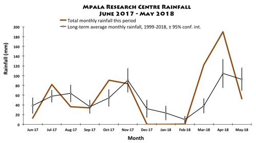
Rainfall is on a mostly bimodal schedule. The 'long rains' fall between April and June and the 'short rains' fall between October and December. However, the rainfall has little predictability and may fall at any time during the year. Warm days and cool nights predominate, with very low humidity in the driest season (January-April), and moderate humidity at other times.
Weather Forecast Pages
Long term forecast for Mpala Farm
Mpala Farm, Kenya Page
| Average Minimum | 12.4°C |
| Average Maximum | 28.1°C |
| Month | Jan | Feb | Mar | Apr | May | Jun | Jul | Aug | Sep | Oct | Nov | Dec |
| Average Minimum | 11.0°C | 11.1°C | 12.6°C | 13.6°C | 13.4°C | 12.5°C | 12.1°C | 12.5°C | 12.4°C | 12.7°C | 12.9°C | 11.5°C |
| Average Maximum | 27.8°C | 29.4°C | 29.5°C | 28.3°C | 28.9°C | 28.4°C | 28°C | 28°C | 28.9°C | 28.3°C | 26.5°C | 26.8°C |


